John Muir Trail 211-Mile Hiking Guide: 21-Day Itinerary
Master the iconic 211-mile trek through California's Sierra Nevada with expert tips on permits, gear, itinerary, and safety.

The John Muir Trail (JMT) stands as one of America’s premier long-distance backpacking routes, stretching 211 miles through the heart of the Sierra Nevada mountains in California. Beginning at Yosemite Valley’s Happy Isles and culminating at the summit of Mount Whitney—the tallest peak in the contiguous United States at 14,505 feet—this trail weaves through Yosemite National Park, Ansel Adams and John Muir Wilderness areas, and Kings Canyon and Sequoia National Parks.
With over 47,000 feet of cumulative elevation gain and 11 major passes exceeding 10,000 feet, the JMT demands physical endurance, mental resilience, and meticulous planning. Most hikers take 18-22 days to complete it, encountering pristine alpine lakes, granite spires, and diverse wildlife amid some of the nation’s most dramatic landscapes.
Why Hike the John Muir Trail?
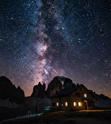
This legendary path offers unparalleled rewards for those prepared to embrace its challenges. Hikers revel in solitude amid jagged peaks, crystal-clear waters, and star-filled nights far from civilization. The trail’s well-maintained path minimizes navigation worries, allowing focus on the journey’s beauty—from the thundering waterfalls of Yosemite to the vast basins below Forester Pass.
- Scenic Diversity: Transitions from lush valleys to high-alpine tundra, with highlights like Thousand Island Lake and the Devils Postpile formations.
- Historical Significance: Built atop ancient Indigenous routes known as Nüümü Poyo, honoring centuries of Native American travel.
- Achievement Milestone: Summiting Mount Whitney provides a profound sense of accomplishment.
Choosing Your Direction: Southbound vs. Northbound
The debate over hiking direction is central to JMT planning. Southbound (SOBO) from Yosemite to Whitney Portal remains the traditional and most popular choice, favored for gradual altitude acclimatization.
| Aspect | Southbound (SOBO) | Northbound (NOBO) |
|---|---|---|
| Starting Point | Happy Isles, Yosemite (4,000 ft) | Cottonwood Pass/Lakes (10,000+ ft) |
| Ending Point | Mt. Whitney Summit/Whitney Portal | Happy Isles, Yosemite |
| Acclimatization | Excellent: Low start builds stamina | Challenging: High start risks altitude sickness |
| Permits | Highly competitive (Yosemite lottery) | Easier via Inyo NF (Cottonwood) |
| crowds | Denser early sections | Quieter overall |
| Distance | 211 miles core + 11 to Portal | ~237 miles incl. Whitney side trip |
Southbound allows hikers to start at lower elevations, ascending progressively to tackle high passes like Forester (13,153 ft) with adapted bodies. Northbound suits those seeking fewer crowds but requires prior high-altitude experience.
Securing Your Permit: The First Hurdle
Permits are mandatory and notoriously difficult to obtain, especially for southbound starts. Yosemite National Park manages the quota system via a lottery opening five months in advance, with only 45 daily slots from Happy Isles amid thousands of applicants.
- Yosemite Trailheads: Happy Isles (most popular), Lyell Canyon, or Tuolumne Meadows for SOBO.
- Inyo National Forest: Easier for NOBO from Cottonwood Pass/Lakes; apply up to 6 months ahead.
- Timing: Peak season (July-early October) books fast; apply early or target walk-up permits (60% released day-of).
- Alternatives: Section hikes or starting beyond Yosemite reduce competition.
Once secured, your permit specifies a start date and trailhead, valid park-wide. Always carry it, as rangers enforce strictly.
Gear Essentials for JMT Success
Packing light is crucial for the trail’s relentless climbs. Aim for a base weight under 15 pounds, prioritizing durability and multifunctionality.
- Backpack: 40-55L ultralight frame, e.g., for 30-40 lb total load.
- Shelter: Tarp or freestanding tent; bear canister mandatory (required by regulation).
- Sleep System: 20°F quilt, inflatable pad (R-value 4+).
- Clothing: Layered synthetics, rain gear, sun hat, wool socks; no cotton.
- Navigation: Topo maps (e.g., Nat Geo 30-map set), compass, GPS backup; trail is signed but weather obscures markers.
- Water: Sawyer Squeeze filter; sources abundant but treat all.
- First Aid/Kitchen: Compact kit, bear canister, stove (isobutane), titanium pot.
Test gear on training hikes to dial in fit and systems. Weather varies wildly—prepare for snow, thunderstorms, and 90°F heat.
Resupply Strategies: Fueling the Journey
With limited access points, resupply planning prevents starvation. Most hikers use 2-3 stops, mailing packages ahead or buying on-trail.
- Red’s Meadow Resort (Mile 60): Store, showers, burgers; earliest major stop.
- Muir Trail Ranch (Mile 108): Pre-paid buckets (order early); hot meals available.
- Vermilion Valley Resort or Bishop (via detours): Flexible but adds miles.
- Whitney Portal (End): Burgers and beer post-summit.
Carry 5-7 days’ food (2.5-3 lbs/day), emphasizing calorie-dense items like nuts, bars, and dehydrated meals. Bear-proof storage is non-negotiable.
Sample 21-Day Southbound Itinerary
This moderate pace covers ~10 miles/day, allowing rest and acclimatization. Adjust for fitness.
- Happy Isles to Sunrise Creek (8 mi, +3,000 ft)
- To Lower Cathedral Lake (10 mi)
- Tuolumne Meadows (7 mi)
- Tarn below Donohue Pass (11 mi, 11,056 ft high)
- Garnet Lake (11 mi)
- Red’s Meadow (12 mi; resupply)
- Rest/zero day
- Lake Virginia (16 mi)
- Bridge Creek (13 mi)
- Marie Lake (12 mi)
- Muir Trail Ranch (8 mi; resupply)
- Rest day
- McClure Meadow (12 mi)
- Pinnacles Creek (13 mi, Mather Pass)
- Deer Meadow (12 mi)
- Taboose Junction (15 mi)
- Middle Rae Lake (16 mi, Glen Pass)
- Center Basin (10 mi)
- Wright Creek (13 mi, Forester Pass)
- Mt. Whitney Summit (11 mi down to Portal)
Key passes: Donohue (11,056 ft), Muir (11,955 ft), Forester (13,153 ft). Camp at lakes for water and views.
Navigating Challenges: Passes, Weather, and Wildlife
The JMT’s high passes demand respect—steep, exposed, and snow-prone early/late season. Forester Pass, the highest, features a knife-edge traverse.
- Altitude Sickness: Hydrate, ascend gradually; symptoms include headache, nausea—descend if severe.
- Weather: Afternoon storms common; start early, monitor forecasts via sat comms.
- Bears: Hang food or use canister; active in Evolution Valley.
- Water Crossings: Early melt causes high flows; use sticks, go early.
Train with loaded hikes and elevation. Leave No Trace: pack out waste, camp 100 ft from water.
Best Time to Hit the Trail
July through September offers snow-free conditions, wildflowers, and warmth. June risks heavy snow; October brings fall colors but nights below freezing. Monitor Sierra snowpack via NOAA.
Transportation and Logistics
- To Yosemite: YARTS bus to Happy Isles; park shuttles.
- From Whitney Portal: Shuttle to Lone Pine, then bus to start.
- NOBO: Drive to Cottonwood, hitch returns.
FAQs
Is the JMT suitable for beginners?
Novices with fitness can succeed via SOBO acclimatization and training, but expect strenuous effort.
How much does a JMT thru-hike cost?
$500-1,500: permits ($5+), gear, food, transport; resupplies add $200-400.
Do I need prior backpacking experience?
Yes—train with multi-day trips totaling 40+ miles.
Can I hike with a dog?
No, pets prohibited in Yosemite and national parks.
What if I can’t get a permit?
Section hike, NOBO, or flip-flop (PCT overlap).
Conclusion: Embark on Your Sierra Epic
The JMT transforms hikers, blending raw challenge with sublime beauty. With preparation, it delivers memories for a lifetime.
References
- How to Thru-Hike the John Muir Trail: A Beginner’s Guide — Outside Online. 2023. https://www.outsideonline.com/adventure-travel/destinations/north-america/john-muir-trail-guide/
- A Complete Guide to Hiking the John Muir Trail — CleverHiker. 2024. https://www.cleverhiker.com/backpacking/a-complete-guide-to-hiking-the-john-muir-trail/
- Hike the John Muir Trail Northbound: A Complete Guide — Lady on a Rock. 2025-04. https://ladyonarock.com/john-muir-trail-northbound-guide/
- Ultimate John Muir Trail Planning Guide (2024) — Bearfoot Theory. 2024. https://bearfoottheory.com/john-muir-trail-planning-guide/
- John Muir Trail — Pacific Crest Trail Association. 2024. https://www.pcta.org/discover-the-trail/john-muir-trail/
Similar Articles


Read full bio of Sneha Tete